Introduction to Geometry of Solids via Augmented Reality (GeoSolvAR)


Purpose of using GeoSolvAR

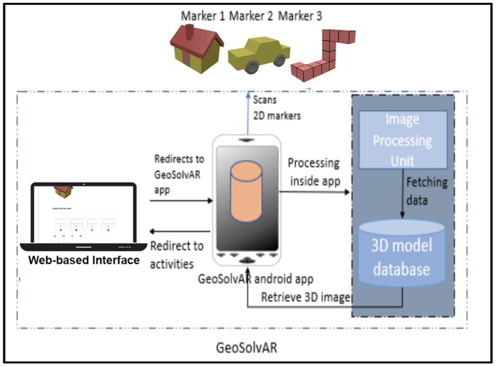
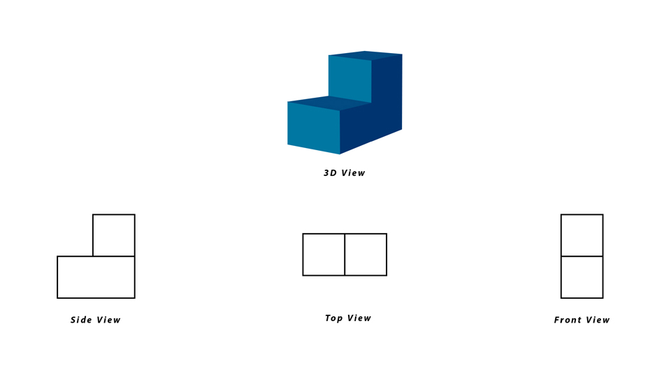
Learning activities in GeoSolvAR are built on the theoretical foundations of Predict-Observe-Explain (POE) strategy to teach concepts of 3D views like top, front, and side view. The activities in GEoSolvAR are facilitated with the use of Augmented Reality application to view the 3D model.


Learning Augmented Reality based Solution for Visualising 3D Solids


Project Team:


  • Navneet Kaur
  • Rumana Pathan
  • Ulfa Khwaja
  • Pratiti Sarkar
  • Siddhesh Walunj
  • Balraj Rathod

Resources required

  • Android phone or tablet running operating system Android 4.0 onwards
  • GeoSolvAR apk file link here
  • Paper markers link here

Getting started with GeoSolvAR

  • To access the web interface of GeoSolvAR, click on the link
  • To download the GeoSolvAR.apk file, click on the download button below. Install the Android application in an Android tablet/ phone with minimum Android OS version 4.0.
Download ZIP
  • If you wish to use GeoSolvAR online, without downloading the software, then click on:
    • Researcher's corner: If you are a researcher.
    • Developer's corner: If you are a developer.

Teacher's corner

Learning Activities with GeoSolvAR

Click on the "Run" button to run a webpage containing learner-centered activities with GeoSolvAR.

GeoSolvAR Run

Researcher's corner

Abstract of the GeoSolvAR work done

Cite as: Kaur, N., Pathan, R., Khwaja, U., Sarkar, P., Rathod, B., and Murthy, S. (2018, December). GeoSolvAR: Augmented Reality based Application for Mental Rotation. To appear in the 9th Proceedings of IEEE Conference on Technology for Education 2018, Madras, India, December 10 - 13.

Abstract:
Mental Rotation (MR) is an important aspect of spatial visualization which is essential for understanding geometry concepts like the visualization of 3D Solids. MR refers to the ability to mentally retain an object and accurately rotate it in space. Performing these tasks has shown to be difficult because it involves a series of manipulations like rotating, inverting, or twisting the objects in the 3D space mentally. To address this challenge, we have developed an MR training application called 'GeoSolvAR' for middle school students. GeoSolvAR is an Augmented Reality (AR) based application, where the use of AR enables the learners to accurately visualize and manipulate complex 3D objects. GeoSolvAR consists of learning activities which involve different types of MR tasks. Each activity consists of four phases-Predict, Observe, Explain and Feedback, where the first three stages are based on Predict-Observe-Explain (POE) strategy. This paper reports the results and observations of a study conducted with six 6th and 7th grade students to examine - (a) how students interact with GeoSolvAR to do MR, and (b) the usability of the application. Redesign measures informed by the results have also been discussed.

Cite as: Navneet Kaur, Rumana Pathan, Ulfa Khwaja, Sahana Murthy (2018, July). GeoSolvAR: Augmented Reality based solution for visualising 3D solids. In the Eighteenth International Conference on Advanced Learning Technologies.

Abstract:
Visualization is an important skill required to understand 3-Dimensional (3D) geometry concepts involving solids. However, 3D visualization is fairly difficult as it involves complex tasks like mental rotation and spatial transformations. Traditional methods of teaching 3D solids concepts such as static 2D images and physical models are not adequate to build these abilities in students. Also, existing geometry software packages restricts the user to interact and manipulate objects on the computer screens and not in real 3D space. In this paper, we have designed and developed an Augmented Reality (AR) based application-GeoSolvAR, that targets middle school students for improving their visualization skills. Learning activities in GeoSolvAR build on theoretical foundations of Predict-Observe-Explain (POE) strategy to teach the concepts of 3D views like the top, the side and the front view. This paper also reports results and observations obtained from a qualitative pilot study conducted on four 7th grade students. Purpose of the study was to know students' perception of GeoSolvAR's role in helping them visualize 3D solids and to encounter challenges faced by them while interacting with GeoSolvAR.


Future work:
The project is closed now but you can explore the following areas:
  • Functional property:
  • The current research has helped students learn concepts of visualising 3D solids such as top, front, and side view. Further research can explore other topics in 3D solid geometry such as “cross-sectional area,” “volume of solids” etc. It would be desirable to include new related learning objectives, such as “developing skills related to visualisation of cross-sectional areas.” For this, we may require building features that support slicing of 3D solid objects using intuitive user interactions.
    Additional training modules or help sections could be added to the App to familiarise the learner with the necessary know-how of the app usage.

    Developer's corner

    Workflow of GeoSolvAR:
    The overall design of GeoSolvAR is based on three important aspects, namely the web-based interface, AR-based android application, and the physical markers (Refer figure 1).
    figure 1: Workflow of GeoSolvAR To provide easy accessibility to the learning activities, the entire content was converted into web-based. The web- based application can be accessed over a network connection using HTTP and can be used in a mobile/tablet browser. The interface contains activities and a button which on click, leads one to the Android-based Augmented Reality application.
    The Android-based application is one of the leading constituents of GeoSolvAR and is Augmented Reality enabled. The application is primarily used to scan 2D image markers and augment their 3D equivalent on the mobile/tablet screen as shown in figure 1. The affordance of this application enables one to view virtual objects in a real environment and runs interactively in real time.
    The marker cards are targets which trigger the 3D models superimposed on the 2D image. The image is recognized and tracked by a mobile/tablet devices camera and serves as an origin to the augmentation. Once the image is recognized, the content associated with it will be displayed as long as the image target is at least partially in the cameras field of view. A very important practice that followed while choosing image targets is to choose an image with feature points which has several edges, corners, etc, which are used for tracking while image processing. Figure 1 summarizes the overall workflow of GeoSolvAR encapsulating all the three aspects mentioned above.
    AR Implementation Flow:
    There are numerous approaches to make an Augmented Reality application. The approach used in GeoSolvAR is marker based and made using a combination of two developmental portals, namely Vuforia and Unity 3D. Figure 2 summarizes the application creation process. Vuforias developmental portal is predominantly used for two purposes, one to create a license key for the application to be developed and secondly to create a database and an image target. To create a database in Vuforia, image targets needs to be added. The Vuforia target manager supports JPG, PNG in RGB or grayscale. The targets do not need special regions/ qualities/ codes to be recognized, in fact, the SDK detects and tracks the features that are naturally found in the image itself, which is then compared to a known target resource database. This database can then be downloaded in the form of a unity package, which can then be imported into Unity 3D and used.
    The development in Unity begins with a project, onto which packages downloaded via Vuforia are imported. 3D models are then embedded into the image targets by choosing the appropriate frame. These 3D models can be either modeled in Unity itself or Blender or can be downloaded via an inbuilt 3D asset store. If one wishes to use customized 3D models, one needs to create them in either unity/blender and import them in the

    figure 2: Summary of application creation process same project. By some additional settings in Unity, an AR based android application can be built which can then be used to view the image targets, scan them, and trigger the appropriate 3D models. This work is licensed under a Creative Commons Attribution 4.0 International License.
    Visitors Count +10K Since 2018